Gorny Altai is famous for its natural beauty. If someone thinks that here you can only admire the ridges and panoramic views, then a big surprise awaits you. Lakes with a transparent or dull-green water surface from the color of algae, passes of varying difficulty, along which you can often move by transport, waterfalls and springs, tracts introducing historical monuments of the past - this is not a complete list of interesting objects of Gorny Altai.
Thanks to the Chuisky tract and well-made country roads, it is convenient to get to most of the attractions. In the cities and towns of the region, tourists are welcome to museums, where guides will tell about the local characteristics and culture of indigenous peoples. If desired, any travel lover will find something to do here.
The most interesting and beautiful places of Gorny Altai
What to see and where to go? List of the best objects of tourism and active recreation!
Ukok plateau
Border territory at the junction of several countries: Russia, Kazakhstan, China and Mongolia. It is characterized by changeable weather and concentration of several types of relief in one place. The Tabyn-Bogdo-Ola mountain range is sacred for Buddhists. Many archaeological discoveries have been made here. The most significant artifact is the girl's mummy, named "Princess Ukok". It is kept in the National Museum of the Altai Republic.

Altai nature reserve
Included in the "Golden Mountains of Altai" - a UNESCO World Heritage Site. It has existed since 1932, but has been eliminated more than once and reappeared on the map. The area is about 881 thousand hectares. Mountain ranges and massifs outline the boundaries of the reserve. More than 30 species of plants and animals are included in the Red Book. There is a threat to the environment due to the fall of detachable parts of rockets launched from Baikonur into the area.

Teletskoe lake
It is located in the Turochak and Ulagan districts of the republic. The area is more than 22 thousand hectares. Average depth - 174 m, maximum - almost 2 times more. There are about 18 tourist bases and campings in the district. Trekking routes have been developed, both walking and boating. Air excursions are popular. Attractions nearby: the Korbu and Kishte waterfalls, the stone bay, the Yaylyu pontoon pine, the Chulyshman delta.

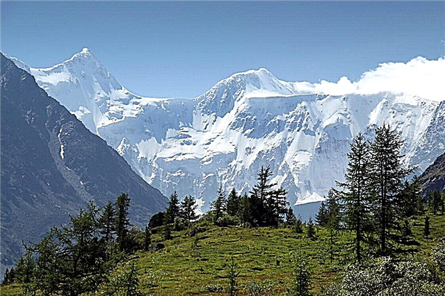
Mount Belukha
The highest peak in the Altai Mountains is 4.5 thousand meters. Located in the Ust-Koksinsky region near the border with Kazakhstan. When visiting an attraction, you need to have a passport with you, and foreigners - an additional permit. Nearby there is a tourist base of the same name, next to the post of the Ministry of Emergency Situations. The mountain is popular among fans of extreme climbs; there are routes of varying difficulty.

Katunsky reserve
Founded in 1991, since 2000 - biosphere. The area is more than 151.5 thousand hectares. Elevation changes within 1.3 - 3.3 thousand m. Included in the "Golden Mountains of Altai" - a UNESCO World Heritage Site. Here, among other things, they are engaged in scientific activities and environmental education. On the basis of the reserve, environmental actions are carried out to draw attention to the problems of preserving the nature of Altai.

Kalbak Tash
It is located in the Ongudai region of the republic. The tract is primarily famous for its petroglyphs. It is noteworthy that the drawings belong to different historical periods and were made with tools of different types. There are images of both scenes from the life of ancient people and symbols that at the moment cannot be deciphered. Although the area is fenced off, access is free and does not require a guide.

Pazyryk burial mounds
Located in Ulagansky district. Items found during excavations on five mounds are kept in the local museum "Pazyryk", as well as in the "Hermitage". The mounds are dated by the 5th-4th centuries BC. Their diameter varies within 24-47 m, height - from 1.5 to 3.75 m. It is believed that the burial sites were robbed in antiquity, the artifacts discovered by researchers have survived due to the permafrost layer.

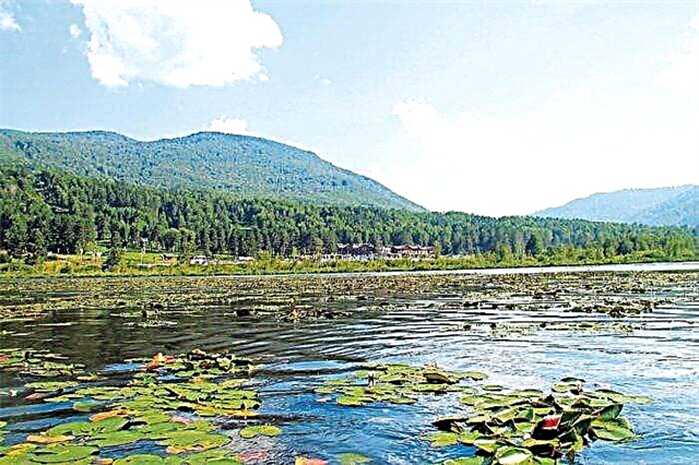
Manzherokskoe lake
It is part of the Mayminsky district. Area - 37 hectares. It is a natural monument. The dirty green color of the water is due to the large number of aquatic plants and the muddy bottom. Recharge from groundwater and precipitation. A ski resort will soon open up nearby. In the warm season, the shores are filled with vacationers. There are excursions, there are equipped places for picnics and tents.
Arzhan-Suu

Karakol lakes
7 lakes in the Chemal region. It is not easy to get to them, as there is no paved road for the car. They are located at different heights - on the steps of the tarmac staircase. The higher the lake, the lower its size and water temperature. The largest has an area of approximately 12 hectares. They are connected by streams and lag behind each other at a distance of 300 to 800 m. The chemical composition of the water in the lakes is different.

Shavlinsky lakes
Two lakes in the Kosh-Agach region. The lower one has a large area; there are many parking areas on its bank. Hiking and horseback excursions from different cities lead here, but the starting point is usually the village of Chibit. The Shavla River flows through the lakes. Plots of forest dominated by larch and individual Siberian cedars are interspersed with hills, which makes the area especially picturesque.

Big Chulchinsky waterfall
Another name is Uchar, which translates as "Inaccessible" or "Flying". It is cascading and stepped; throughout its entire area there are large stones that create additional volume. According to formal criteria, it is precisely a ridge, not a waterfall. You can find it in Ulagansky district. Height - 160 m, which makes Uchar the largest in the republic. Belongs to the territory of the Altai nature reserve.

House-Museum of N.K. Roerich in Altai
The creation of the museum began in 1990. Roerich was known not only as an artist, but also as a researcher. In the 20s of the last century, he went on an expedition covering a long route and several countries. Roerich spent almost two weeks in Altai and stayed at the estate in the village of Verkhniy Uimon. The original building was lost and restored according to photographs, and the exposition was located in it: personal belongings, finds, paintings.

Kamyshlinsky waterfall
Formed on the Katun River in the Shebalinsky region. Two cascades are 12 m high. You can go to the waterfall by different paths, and the shortest road is laid across a special bridge from the Tsarskaya Okhota tourist complex. The entrance is paid, but it allows you to better view the area. Below, on the stones, there are logs from an old water mill. It is a regional natural monument.

Patmos Island on the Katun River
Location - Chemalsky district. The island resembles a rock, the shores are sheer walls. It is connected to the mainland by a long, narrow suspension bridge. The name refers to the Greek island. A temple was built here in the second half of the 19th century. It was destroyed after the revolution, and was recreated in the 2000s. Now the temple belongs to the Znamensky women's monastery, but everyone can attend the services.

Saylyugem National Park
Founded in 2012 on an area of more than 118 thousand hectares. Its purpose is primarily to protect the small population of the snow leopard and its habitats. According to researchers, about 40 individuals live here. Sightseeing: museums in the villages of Kokorya and Zhana-Aul, Dzhumalinskie Klyuchi, a canyon 5 km away on the Argut River, the southwest of the Saylyugem ridge (petroglyphs) and others. To visit the park you need to get a special pass.

Seminsky pass
Crosses the mountain range of the same name. The height is about 1.7 thousand m. They rise along the northern side (length - 9 km), and descend along the southern side (11 km).In the middle of the last century, a stele was erected at the top - a symbol of the voluntary annexation of the Altaians to the Russian Empire. The pass is a natural monument of national importance. Nearby is the "Seminsky" - a roller ski training center.

Chuisky tract
Federal highway passing through three constituent entities of the Russian Federation: the Novosibirsk region, the Altai Territory and the Altai Republic. Ends at the border with Mongolia. The length is about 968 kilometers. A full-fledged museum opened in Biysk is dedicated to the road. The exposition tells about the construction and significance of the highway. Traveling along the tract, you can visit many sights and tourist areas.

Pass Katu-Yaryk
Belongs to the Altai Mountains system. The descent is quite steep and is almost 4 km long. Only vehicles with high cross-country ability can overcome the pass. The road leads to the valley of the Chulyshman river. Until 1989, it was impossible to move by car here, horses and a waterway along Lake Teletskoye were used. Since 2011, a new pass has been under construction, which should simplify transportation.

Korbu waterfall
Formed on the Bolshaya Korbu River. Height - 12 m. The stream is not wide, but powerful and falls down with a roar. In 1978 it was recognized as a natural monument. It is part of the Altai State Natural Biosphere Reserve. You can get to the attraction only by boat or speedboat on the lake. Winds often rise here, which must be taken into account during the training camp.

National Museum of the Altai Republic
Location - Gorno-Altaysk. Its history dates back to 1920, although funds began to be collected even earlier. Subsequently named after its first director - A.V. Anokhin. The collection consists of archaeological finds, ethnographic exhibits, old books, both handwritten and printed, collections of minerals found in the region, items of national crafts and art.

Akkurum tract
Occupies a section of the right bank of the Chulyshman River. The tract looks like an accumulation of myceliums - bizarre rock formations that appeared due to weathering of the rock and erosion by precipitation. Despite the tremors, some of the "hats" remained in place and survived to this day. Similar anomalies are found in other parts of Altai, but in Akkurum you can come close to them.

Gorno-Altai Botanical Garden
It was founded in 1994 in the Shebalinsky region and bears another name "Clean meadow" (after the tract located nearby). Area - 11 hectares. The collection consists of over 1,500 plant species. Samples of local flora predominate, but there are representatives of the Far East and other regions. Flower festivals are held on the basis of the garden. The entrance is paid, as is the shooting. You can buy seeds and seedlings.

Kucherlinskoe lake
It is located in the Ust-Koksinsky district. The name comes from the river that flows through the lake. Area - 300 hectares. The average depth is about 30 m. One of the largest reservoirs of glacial origin in the region. The location on the side of the mountain and alpine meadows make the local views especially picturesque. Snow leopards sometimes come down here. Trout has also been launched into the lake.

Multinsky lakes
Five lakes in the Ust-Koksinsky district. The largest of them is Nizhnee, the length of the coastline is 6.5 thousand meters. Verkhnee and Poperechnoe are part of the Katunsky Biosphere Reserve. The cascade of lakes belongs to the upper and tributaries of the Multa River. Bitter Revyakina - a mushroom of the Russula family does not grow anywhere else in the world. There are also other rare species in the area.

Museum of History and Culture of the Uimon Valley
Discovered in the village of Verkhniy Uimon. Originally a private initiative, it has grown over the years. One of the main themes is the Altai Old Believer culture. The museum building is a wooden house with traditional utensils and furniture inside. An authentic barn is built nearby. During the excursion, tourists are not only told about the life of an Old Believer, but also about their traditions, rituals and how the culture of the community spread throughout the district.

Aktru glaciers
They are located in the Kosh-Agach region on the tops of the Severo-Chuisky ridge. Height - 2.1 thousand meters. Since the relief is ragged, individual ridges and dissection are clearly visible, the terrain becomes the most suitable for the accumulation of snow and the formation of glaciers. Aktru unites 5 glaciers. The largest - Bolshoi - has an area of one thousand hectares. The rest have their own characteristics from appearance to location on the map.

Altai Stonehenge
The attraction is located 20 km from the village of Kosh-Agach. Ancient petroglyphs remain on the huge boulders, and their arrangement speaks of human influence. The main "exposition" includes five stone slabs of different sizes, although there are still many small stones nearby, also attributed to Stonehenge. The composition of the rock showed that the boulders are not from these places. Legends attribute ritual and mystical meanings to them.

Colored mountains of Kyzyl-Chin
They are located near the village of Chagan-Uzun. The name speaks very eloquently about their appearance: a rich color palette makes this natural object unique. The reason for the appearance of so many shades is the abundance of polymetallic ores. Minerals and rock outcrops replace each other in different areas, so the color is not uniform. Directly to the mountains you can drive by car - the road allows.

The Katun river
It starts on the slope of Belukha. The length is 688 km. It is navigable and of key importance to the region. The source is the Gerbler glacier, the mouth is the Ob. There are many rapids on the river, which makes it interesting for rafting. The confluence with Biya and the Blue Lake are natural attractions. Various legends are associated with the river; it is mentioned in the legends of the Old Believers.